

The smartphone app “World Transit Maps” operated by TOKYO STUDIO Inc. currently offers railway route maps from 11 countries and regions across Asia, Europe, and North America. The Japan railway map will be compatible with the new display method “tile method (v2)” from Friday, November 8, 2024.
Background to the transit maps renewal
This app was launched in January 2015, and initially used a “download method” in which large, single-image images prepared for each area were downloaded to the devices to be browsed. Despite the constraints on image size, the maps was designed to ensure ease of viewing, such as intentionally increasing the area allocated to city centers where many lines are spread out. The “deformed” design was one of the app’s popular features, but the geographical layout and distances between stations were significantly different from reality. In addition, when starting to use the app or switching areas, it was necessary to download a large-sized map image.
To overcome these weaknesses in usability, we developed a new “tile method (v1)” that loads small tiled images into the display area of the screen in real time, without the need for pre-downloading. From September 2023, we gradually supported railway maps of Hong Kong, Macau, and Taiwan, and also eliminated the need to switch maps at area borders within the same country or region, greatly improving convenience. These maps has also evolved to be closer to the actual topography, but because we followed the previous design taste as much as possible, the route shape remained linear.
Recently, the use of map apps on smartphones has increased, and it is becoming common to check your current location and route on a realistic map while out and about. We thought that our railway maps app also needed to be “realistic” rather than “deformed,” so we carried out a major update to keep up with the changing times.
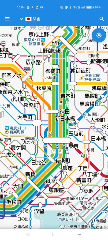
Going from “deformed” to “realistic”
The Japan railway map, which is the first one to be released with a “tile method (v2)”, has been completely redesigned from scratch, and is the first to adopt a design that faithfully reproduces the actual shape of the route. You can now accurately see curves, parallel routes, and distances between stations. The well-established ease of viewing has been further refined, with the line colors and route symbols used in the signs on-site being reproduced.
Especially in urban areas, the content is displayed according to each scale to avoid cluttering the display, and all lines and stations can be displayed by enlarging the map. Of course, the tile format eliminates the hassle of pre-downloading and switching areas, making it even more convenient to use.
Going forward, we will gradually expand the number of countries and regions that support the “tile method (v2)” and establish a system that can support rail travel around the world with the same convenience. In addition, we will improve various functions and further evolve the app into a route map app that can be used comfortably as a companion for everyday moving.
The “World Transit Maps” app will soon be celebrating its 10th anniversary, so please look forward to future developments.

Install


Supported Versions
To use the “tile method (v2)”, you must update the app “World Transit Maps” to version 8.2.2 or higher (for both Android and iOS).
Countries and regions where maps are provided in the app “World Transit Maps”
Asia
- Japan (v2)
- South Korea
- Taiwan (v1)
- Hong Kong (v1)
- Macau (v1)
- Thailand
- Malaysia
- Singapore
Europe
- United Kingdom
- France
North America
- United States
*(v1) supports “tile method (v1)”, (v2) “tile method (v2)”, and no mark “download method”.